My next walk is this Wednesday and Friday which aptly should include the Black Death. At present I have another man-cold which probably isn’t as bad as full blown plague but certainly helps me empathise. I am writing this in case I decide to cancel my walk if I don’t get any better…
Early Medieval Downs
The earliest discovered and excavated, culturally Saxon, post-Roman, settlements on the Downs were on ridge-tops. Later in the mid-Saxon, early Medieval period (8th century), these settlements moved down into valley bottoms, eventually becoming the villages which survive today. Bishopstone (near Newhaven) was one of them. From such limited information it was initially presumed that the earliest Saxon conquerors, nervous of attacks from local Britons, congregated on the hilltops. The more sheltered valley bottoms were only occupied some two or three hundred years later, once the native Britons had been driven out of the area.
However, since the advent of sophisticated DNA testing, isotopic analysis, better dating techniques and a significant number of early post-Roman (culturally Saxon) valley bottom sites also having been discovered, this story has changed. Simply speaking, hilltop sites are easier to find, and the peoples who were considered to be Saxon invaders turn out to be almost all native British who had adopted a largely Saxon way of life. However, during what some now call the early Medieval period (for our purposes, 8th to 10th centuries), many of our villages and farm settlements did establish a new valley bottom existence.
Most of our local ancient South Down farms and villages, from placename evidence, were established or continued their existence in this period:
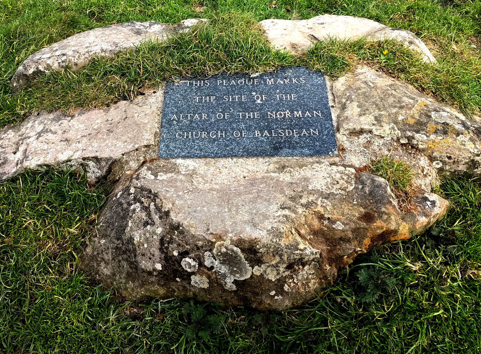
- Balsdean — Beald’s valley;
- Bevendean — Beofa’s valley;
- Falmer — Fallow mere, dark pool;
- Kingston — King’s farm/settlement;
- Ovingdean — Valley of Ufa’s or Ofa’s people;
- Rottingdean — Valley of Rota’s people;
- Woodingdean or Woodendean — may be an exception, first appears unnamed as an isolated farm or outfarm, to the south of the modern village, on a 1714 map and may have acquired its name by copying the form of others in the area.
The latest thinking is that these peoples’ names, recorded in the names of their settlements, were not heroic Saxon warriors, conquerors of little corners of England. They were just local leaders, farmers, estate managers — founders of new farm settlements, but worthy of being remembered all the same. Kingston near Lewes was not the residence of royalty, a great chieftain, but merely one of many royal landholdings, bringing in an income to swell their coffers.
An observation of my own (which may or may not be original) relates to their geography. They are (almost) all located:
- In the shelter of a ridge to their south-west, the prevailing wind direction;
- At the coming together of two or more valleys; the exceptions, Falmer and Kingston, had a permanent pond or a spring respectively.
- All of these factors would mean that their valley bottom soils would potentially be deeper, have a larger collection area for the run-off of rainfall, and the effects of winter gales would be less — hay ricks would be less likely to blow away (a problem reported by Woodman for Balsdean).
The locations of settlements at the meeting point of two (or more) valleys would have served a further purpose. Their arrangement is like that of a capital ‘Y’, consisting of two upper branches and one lower, with the farmstead in the middle. This enables the classic Medieval three field system – one in each of their fertile bottoms – a system possibly developed in the 8th century.
Medieval Downs
The Norman Conquest brought new landlords, but our Downland peasants remained the same; sowing and reaping, baking and brewing, shepherding and milking. One new landlord, in about 1130, was the Lewes Cluniac Priory, whose prior was brought over from France by William de Warren, who fought with William the Conqueror at the Battle of Hastings. He gave them land, churches, mills and other industries, along with the people who looked after them, all from his holdings in thirteen counties, so they could pray for his and his family’s souls in perpetuity. Others made more modest donations. Lewes Priory’s Chartulary included many of those places mentioned in this book:
- Balmer; (1091–1098) William de Warren gave 2 hides [the amount of land sufficient to support 2 (extended?) households]; and a hide of land which Eustace held and which belonged to the manor of Falmer; Godo also gave 2 hides;
- Balsdean; (1091–1098) Hugh son of Hugh gave a hide; (1095) William de Warren gave the chapel; (c. 1175) Earl Hamelin de Warenna gave 100s. of land in Balsdean, namely 2½ hides and 1 virgate of land [a quarter of a hide] for the welfare of my soul and of Countess Isabel my wife and our children and for the souls of our ancestors, in free alms. Wherefore I will and firmly command that the monks have and hold the said alms well quietly freely and honourably as free and perpetual alms. And I and my heirs will acquit these lands at our own cost towards the King and towards all men from all customs and services. And the monks after our death shall celebrate the anniversaries of Countess Isabel my wife and myself;
- Brighton; (1091–1098) Wiard gave half a hide and the tithe of his demesne [the land retained and managed by a lord of the manor for his own use]; (c. 1095) Ralph de Kayneto gave the church and the tithe [a 10% tax on all things for the church] which he had in that vill [land in a parish or manor]; William de Warrena gave two churches [!!] and in the same vill half a hide of land; (c. 1147) John de Kaysneto gave to God and St. Pancras and the monks half his land of Bristelmeston [Brighton] which his father had on the day when he was alive and dead, with all the men belonging to the land and with pasture and its other appurtenances; (c. 1090) William de Warrena also gave the tithe of my hay and half a hide of land at Bristelmestona which was Wiard’s, and Brithmer de Bineham with the land which he held of Ralph son of Warin; (c. 1175) William de Garenna gave 2 virgates of land and the third part of a quarter of a virgate of land with all its appurtenances in the vill of Brittelmeston, which lands Ailwin the skinner (peletarius) and Aluric Asse hold. These men I have given to the said monks with the said land and with their wives and children in exchange for the mill of Mechinges [Meechings, Newhaven] which my father gave them in alms when he himself became a monk at Lewes;
- Falmer; (c. 1089) William de Warrena gave to them the underwritten manor of Falemera by name whatever [he] had in demesne there; (1091–1098) and in Crandona [Crandean, Falmer] the land which Hudelin [or Hugelin] held; (c. 1095) and the land which the burgesses of Lewes held in Crandona; and the land which Wlwin son of Golle used to hold there; (c. 1150) and two hides of land in Falemela which William de Sancto Pancratio held; and in the same Falemera two hides of land which belonged to Plumpton; a hide of land at Falemera all of which Fredesend daughter of Hugh son of Rainer gave for the soul of her father;
- Iford; (c. 1100) William de Warrena gave the church of Iforda with its appurtenances, and the marl-pit which is at the end of [their] vill, with the land which is there round the marl-pit, and the meadow which belongs to the same land; (1091–1098) the church of Yford which Hugh son of Golde gave them [Iford almost certainly had only one church, so Hugh gave the church but William may have ‘owned’ Hugh]; And the tithe of Hugh son of Golde; (? c. 1145) William de Warrena also gave to the same monks in the same freedom two hides in Yfordia which Guy (Wido) de Menchecurt held, to hold in free alms until the said land may be freed from all claims and the monks may possess it quietly and peaceably for ever; also two hides of land in Yfordia which William son of Godwin holds and [William de Warrena] gave to them William himself with his children, so that William himself may hold from them one of those hides for 30s. so long as he pays them properly, but the other hide they may have in demesne as their own;
- Kingston; (1091–1098) Warin the Sheriff gave a garden in the vineyard, and all his tithe of Kyngestona; Hugh son of Golde gave in Kyngeston the tithe of two hides; And a hide and a half of land which Ailwin de Wincestria held in Kyngestona; (c. 1095) And William de Warrena willed the church of Kyngestona with one acre of land (which Peter the Sheriff gave there for the making of the church) on which the church stands with its appurtenances and in the same will 8 hides of land; (c. 1138) And three hides of land; (c. 1090) And half a hide of land and the gift which Richard de Essarz made to the monks, namely, a hide of land in the same Kyngestona in free alms.
- Ovingdean; (c. 1095) William de Warrena gave an Ouingedena a hide of land; (?) Jordan de Blosseuilla gifted the land of Ouyngedena; (c. 1170) Isabel Countess de Warenn’ with the goodwill and consent of her lord Hamelin Earl de Warenn’ grant and confirm the gift which her said lord has made to God and St. Pancras and the monks of 24 hides of land in Ouingedene;
- Rodmell; (1091–1098) William de Warrenagave the tithe of all things at Redmelde; (c. 1095) And the church of Radmelde;
- Rottingdean; (1091–1098) William de Warrena gave the church of Rottingedena; And the tithe of the land which he had in Rottingedene; And a hide of land which William de Petroponte gave in Rottinged; (c. 1095) And in the same Rottingedena a hide of land and a messuage beside the cemetery; (1147) half my land of Rottingedena, with men and pasture and all other appurtenances of that land free quit and discharged of all things, as it was divided in the year in which I went to Jerusalem; And Rainald de Warenn’ allowed that hide of land to be given to God and St. Pancras and to him which Ralph de Angieus has given him of his land in Rottingdena;
- Swanborough; (c. 1089) William de Warenna gave in perpetuity the underwritten manor of Swambergha (c. 1090, 1095 & 1331, Swamberga, the land which Bristelm had, with all the liberties privileges and appurtenances whatsoever); (1091–1098) And in Swamberga 5½ hides; Tusard gave them two hides;
Medieval Brighton
The above (slightly edited) document extracts were included in some detail because it provides a fascinating insight into the area and people of that time. Of importance to this history are the first signs of the rise of Brighton — a strong influence on the later history of the Balsdean and Kingston Downs. In the Domesday Book of 1086 Brighton was a village of fishermen and farmers, with the former being the most important. Based on its evidence, Brighton may have had a population of about 400, which is more than double the size of 19th century Kingston. The Priory’s foundation document, just 9 years later, recorded it as having two churches — a small village would only have one — it is better described as a small town, or at least on its way to becoming one. By 1312 it had been granted a weekly market and an annual fair. Brighton’s earliest map, of 1514, shows it to be a small town formally laid out in a grid pattern, strongly suggesting that its fishing industry was sufficiently important for money to be invested in the town’s layout, sometime between the late 13th and 15th centuries.
All of this has been strongly influenced by Brighton’s geography. It is in the centre of a wide bay between Selsey Bill and Beachy Head, where the coastal plain to the west, meets the chalk cliffs to the east. It is also midway between two important Sussex rivers, the Adur and the Ouse. Both are tidal beyond the points where they cut through the north scarp of the South Downs, and provided strongly defensible harbours inland of the coast. Both are guarded by Norman Castles, and formed important administrative centres. Lewes, the county town of Sussex, was the chosen base of the Barony of William de Warrene, who owned all three of the manors which held land in Brighton. Brighton’s main manor, which was responsible for Brighton’s fisherfolk, was a joint manor with Lewes. Easy access to networks of trackways across the well-drained South Downs linked transport by sea and land.
Tidal currents of the English Channel, as was mentioned earlier, create a phenomenon known as longshore drift. It causes flint pebble beaches to move eastwards, blocking the mouths of rivers and forcing them to exit further east. Thus the action of the sea helped create ancient harbours at Portslade (Aldrington) and Seaford, whose entrances were a considerable distance away from their modern day equivalents at Shoreham and Newhaven respectively. Such secure, protected, river based harbours were largely used for the transport and trade of high value goods, and since the Adur and the Ouse were tidal past their crossings of the Downs, the affluent inland towns of Steyning and Lewes built castles to protect their inland ports, enabling merchants to become rich enough to build fancy houses and make names for themselves.
Meanwhile the wide shingle bar south of Shoreham extended many miles eastwards, as far as Brighton’s Poole Valley. Created by the actions of the Adur and the sea, part of it survives today under Hove Lawns. This extensive beach provided the location of Brighton’s missing street. The 1514 map shows North Street, with West Street, Middle Street and East Street ending at the edge of a low cliff. But down on the beach itself was the former location of South Street, where many of the town’s fishermen lived. A series of storms in the late 17th century and the Great Storm of 1703 caused its demise (of which more later).
Apart from the escape of King Charles II, until it became a fashionable seaside resort, it possessed no nationally important persons or buildings. But the fancy buildings and people of Shoreham and Steyning depended on riverside docks that were expensive to maintain; requiring dredging and repairs. But Shoreham’s flint pebble nuisance was both Medieval Brighton’s greatest asset and its eventual downfall, as we will discover.
Of Fish, Juggs, and the Black Death
The ancient trackway from Brighton to Lewes which crossed Newmarket Hill was called the Juggs Road. Written tradition has it that the name Jugg was a nickname for Brighton’s fishermen and the track bearing that name was used by their wives taking their fish to market over the Downs to Lewes. Some say they carried their fish in earthenware jugs, others have said baskets, perhaps with the help of a donkey. But reading the earliest references I can find, dating from the mid-19th century, this was an old custom which none of the authors had witnessed, for at that time Brighton fishermen were called Jaspers, not Juggs. This traditional story is therefore hearsay and potentially unreliable. The following story is my own reinterpretation, but unlike the traditional tale I have attempted to do my homework.
The Dance of Death
My story starts with the black death of 1348–9. Its effects on society were dramatic to say the least. About half of Britain’s (and Europe’s) population died. Less well known was that this was just the horrible grand finale to a ‘dance of death’ that started less than ten years earlier. Right across Europe in the early 14th century famine was common. From tax records of 1340 we know that locally, in 1339 and 1340, two bad harvests due to extremely cold winters and hot, dry summers, resulted in death and suffering:
- Rottingdean (of which Balsdean was a part): 240 acres uncultivated because of ‘the debility of the land and the inability of those who used to cultivate it’;
- Falmer: 120 acres not sown, ‘from the poverty and inability of the parishioners’;
- Rodmell: 80 acres unsown, ‘because they have not the means of sowing them’;
- Iford: 110 acres unsown, ‘from the poverty of the land and the poverty and inability of the cultivators’;
- No record survives for Kingston; presumably they suffered a similar fate.
‘Debility…’ [and] ‘poverty of the land’; an indication of uncultivable flooded fields;
‘Because they have not the means of sowing them’; suggests a lack of seed corn (recorded elsewhere) — starving people forced to eat that part of their grain which must be set aside for sowing the following year;
The ‘poverty… of the parishioners’ [and] ‘inability of those who used to cultivate it’; speaks for itself.
One year’s bad harvest has consequences that go far beyond that single year. Then, to compound this disaster, 1340 was yet another cold wet winter and dry summer that caused yet another bad harvest. Such famines resulted in millions of starving people, right across Europe, all with a higher susceptibility to disease. An indication that this may be true is that rich people, with better access to food, survived the Black Death far better than the poor. Such famine followed by plague was known at the time as la danse macabre — the dance of death. Already, by the start of the 14th century a rising population was putting pressures on the land to support them. This, followed by bad harvests and the Great Plague — the first and worst of a series of plagues — all these caused a reduction of the local population by about a third during this century.
Consequences for Balsdean and Brighton
A traditional Medieval village was more or less self-reliant. The labourers grew the grain with the help of tools made by the local blacksmith and carpenter; the miller ground the corn into flour for the baker to make into bread; the brewer turned the barley into ale; the women milked the cows and spun and wove both the linen and the sheep’s wool into a variety of garments. And all were answerable to the Lord of the Manor or his stewards.
However, the shortage of labour resulted in changes to the traditional feudal system. Most people used to be villeins (not villains!) — they worked directly for the lord of the manor in exchange for a cottage and enough land to enable a subsistence living. Market forces enabled them to ask for wages, and those already receiving wages could demand more. With more money in their pockets some bought more land, and sold their surplus food in the markets at Lewes or Brighton.
Remote Downland villages such as Balsdean were ‘severely affected’. It shrank from a village to a small hamlet of two farms. Others disappeared altogether. This depopulation was not just due to famine and plague. Those in charge of this remote downland village would have struggled to meet these higher wage costs. Therefore a switch from a mixed arable to a much more specialised pastoral economy — the keeping of sheep — would be far more profitable enterprise. Sheep require far less labour to manage. But there would have been consequences.
However, without wheat for flour they would have to buy their bread, or at least the necessary ingredients, from the weekly markets either in Lewes or Brighton. Shops at this time were more or less non-existent. Kingston would have used Lewes market, but Balsdean probably looked to Brighton to supply its needs. It was part of Rottingdean, and Rottingdean had been part of the same hundred (a collection of villages for administrative purposes) as Brighton.
Needless to say, there were many new business opportunities available in our towns and cities. Many made their fortune as entrepreneurs, including the real-life Dick Whittington, who was born shortly after the Black Death. Though he wasn’t poor and didn’t have cat, he did make his fortune in London as an importer and exporter of fine cloths, including much sought after fine English wool. Balsdean may have looked to supply weavers with fleeces, though possibly not of the high quality demanded by Richard Whittington.
Brighton, as a market town steadily grew, and with its newfound money was able to invest in fishing boats capable of exploiting lucrative North Sea cod and herring. Tough, dangerous work, but the rewards were substantial.
Jugs of Ale Served by Joan or Judy
Meanwhile, all this enterprise would be thirsty work. Alehouses served ale or wine to increasing numbers of customers, no longer able or wanting to brew their own. The vessel they would be served in, shortly after the arrival of the Normans was called a ceac (pronounced cheyak or simply jack, like the boy’s name); Chaucer’s characters, created shortly after the Black Death, enjoyed “breed and chese, and good ale in a jubbe” (The Miller’s Tale); so some have suggested onomatopoeic origins — a name that sounds like the noise it makes — ‘jack-jack-jack…’, ‘jub-jub-jub…’. But the actual word jug first appears after Chaucer, in the 15th century, as a nickname for low class women generally called Joan, Jenny, or Judith, the sort of women who may have served ale in a jack or jub. It only appears as late as 1538 for the name of the vessel from which they would have poured the ale. My theory, in line with Wedgwood’s Dictionary of English Etymology, is that jug, as a vessel for pouring liquids, originated as a portmanteau or blend word, combining jack and jubbe with the nickname for the kind of woman who would have served ale or wine with it. Its derogatory use for women can be seen from certain quotations:
- Ruff: I will give thee sixpence to lie one night with thee.
Mer: Gogs heart, slave, dost thou think I am a sixpenny jug?
Thomas Preston’s play, Cambyses, 1569. - Fool: Whoop Jug [1623 Jugge] I love thee.
Shakespeare, King Lear, IV, 219. - …the sordid temptations of the jug and the bottle, …
Robert South, Shamelessness in sin, the certain forerunner of destruction: in a Discourse Upon Jeremiah VI, 15.


6 replies on “Medieval Balsdean Walk and the Black Death”
Hi Dave Are you doing the walk on Friday? Can you let me have a link to your itinerary? Thanks Martin
Hi Martin,
Right now I have a bad cough/cold, so unless I am not feeling any better on Friday I will be cancelling the walk. However I will turn up to meet and greet any potential customers even if it is to say that the walk is cancelled.
The walk (if it happens) starts at 1pm from the Castle Hill car park just north of the junction of Bexhill Road and the Falmer Road, Woodingdean. All of my summer history walks in the B & H Council Healthwalk programme start at the same time and place and end at 5pm, however I may shorten the walk.
I also have a Saxon history walk in the programme on Saturday, same time same place, though the route and content will vary. The walk theme is always adapted to suit the audience.
Sorry I can’t be more certain. I can however keep you posted by adding a new comment here nearer the time.
Recently there was a Medieval Balsdean Healthwalk listed for tomorrow, Aug 1st 2024. Now it isn’t listed. Will the walk be going ahead?
I had meant to cancel it some time ago as it was accidentally published on the council Healthwalks programme as happening back in May. But I’m (almost) always happy to go for a walk. If you would like to join me tomorrow, 1pm at Castle Hill Car Park, Woodingdean, that would be great. I may still cancel though if the yellow warning of thunderstorms is still active! Cheers. David
Hi David,
I’ll be there. Thunderstorm warning is mostly for the evening so I think we’ll probably be fine.
1pm tomorrow unless I hear otherwise. Will you put a cancellation notice on here if that’s what you decide?
Kev
Yes, I’ll post any updates here.