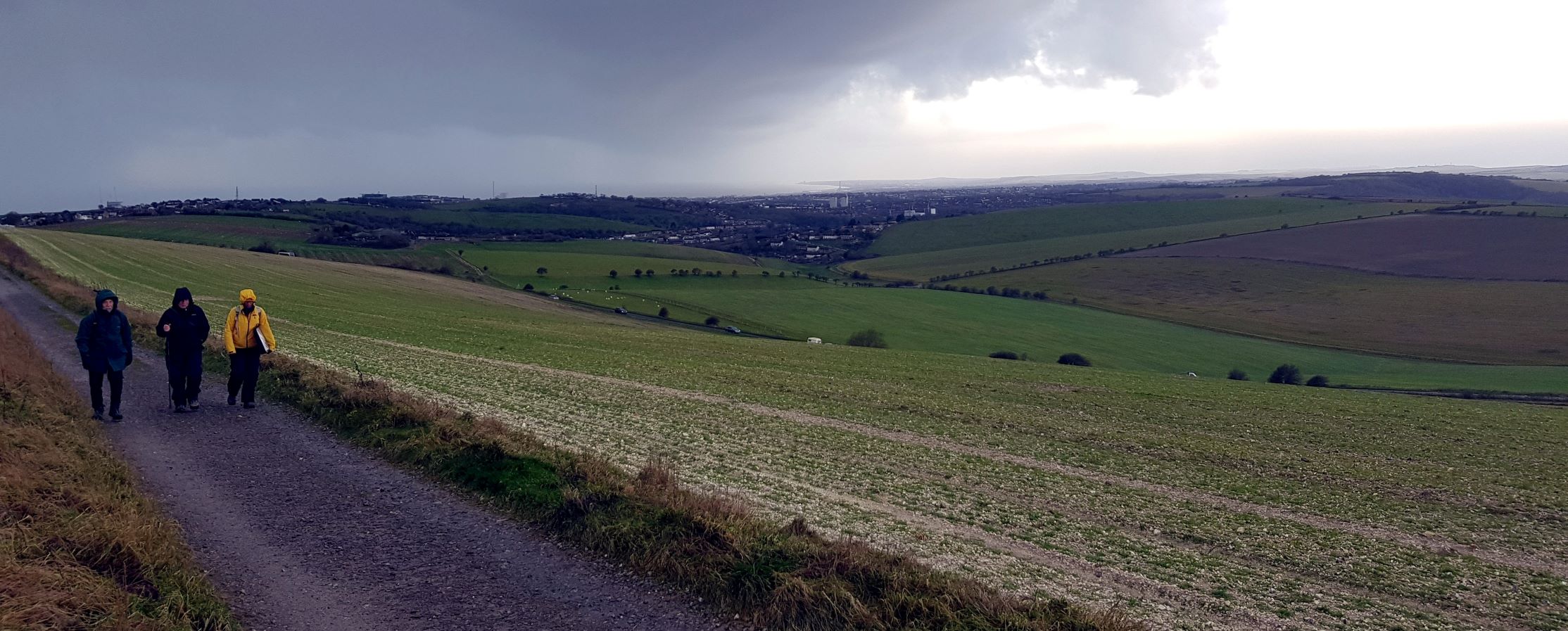
Sunday’s guided history walk was wild, wet and windy, but well worth the challenge. A hardy few joined me for a challenging morning full of life and death through some 5,000 years of history.
Our first stop was a short excursion of a few yards along the headland of a muddy ploughed field immediately to the south-west of the aerial which dominates the skyline of Newmarket Hill. From this point the iconic Mount Caburn magically appears in a notch between Kingston and Swanborough Hills. Mount Caburn lies about north-northeast of this point. One day I hope to find out if there is an alignment with the mid-summer sunrise.
On this spot a Bronze Age bell barrow may have been located, some 5,000 years ago. I spotted the vaguely circular plough mark back in 2012 on the aerial photo, and it was identified by Greg Chuter, then Assistant County Archaeologist for East Sussex.
Newmarket Farm – Birth and Destruction, Death and Disease!
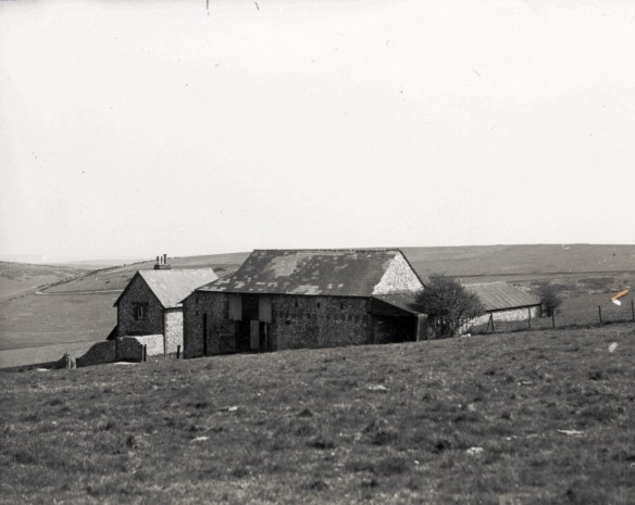
Behind the aerial, due east across the field, in a relatively sheltered hollow, and in what is now the topmost corner of Castle Hill National Nature Reserve, was the birthplace of my mother. In 1942, just one month after my mother’s birth, the cottage and all of the downs to which it belonged was requisitioned by the military for training purposes. As a result it was destroyed and was sadly never rebuilt.
Before that it had been known, at least to the Copper family of Rottingdean, as Baldy’s Cottage. Tragically, this farm labourer’s cottage became famous for David Baldy’s murder in 1868. Continuing my theme of death and destruction, I also told the tragic story of the Rich family. They were the previous tenants to the Baldy’s.
WW2 Dakota Crash Site
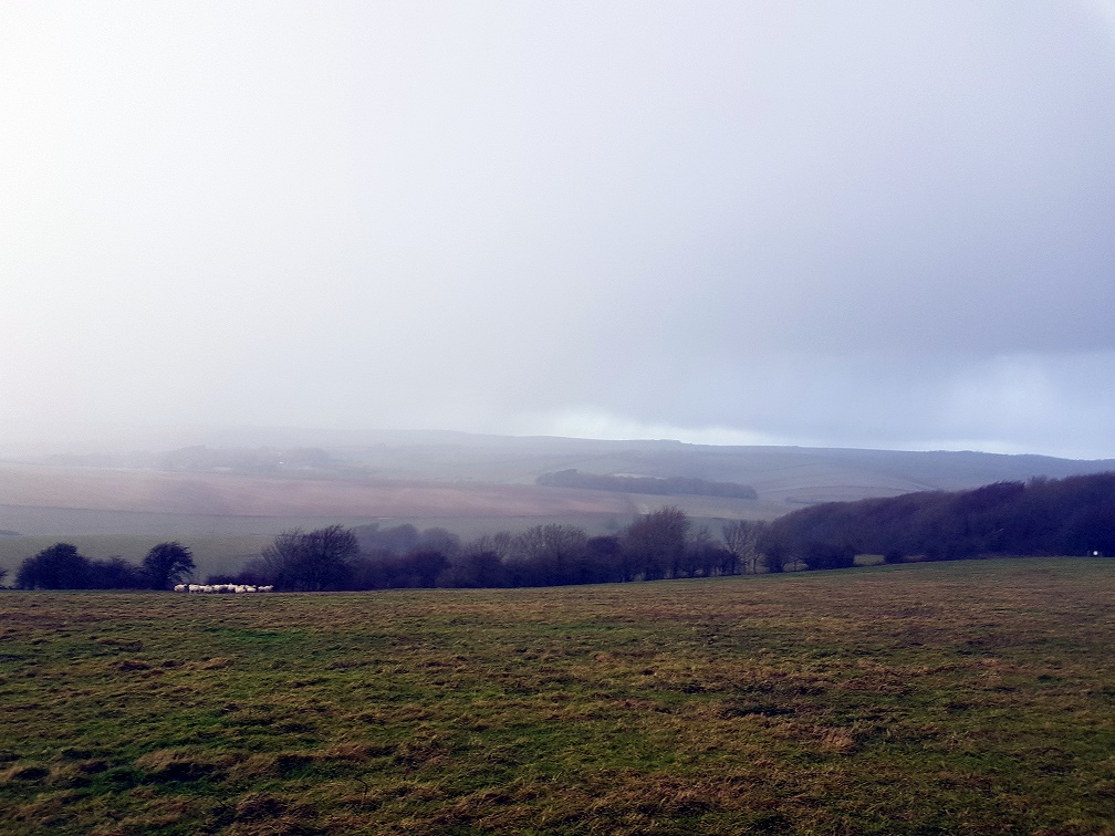
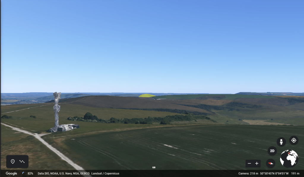
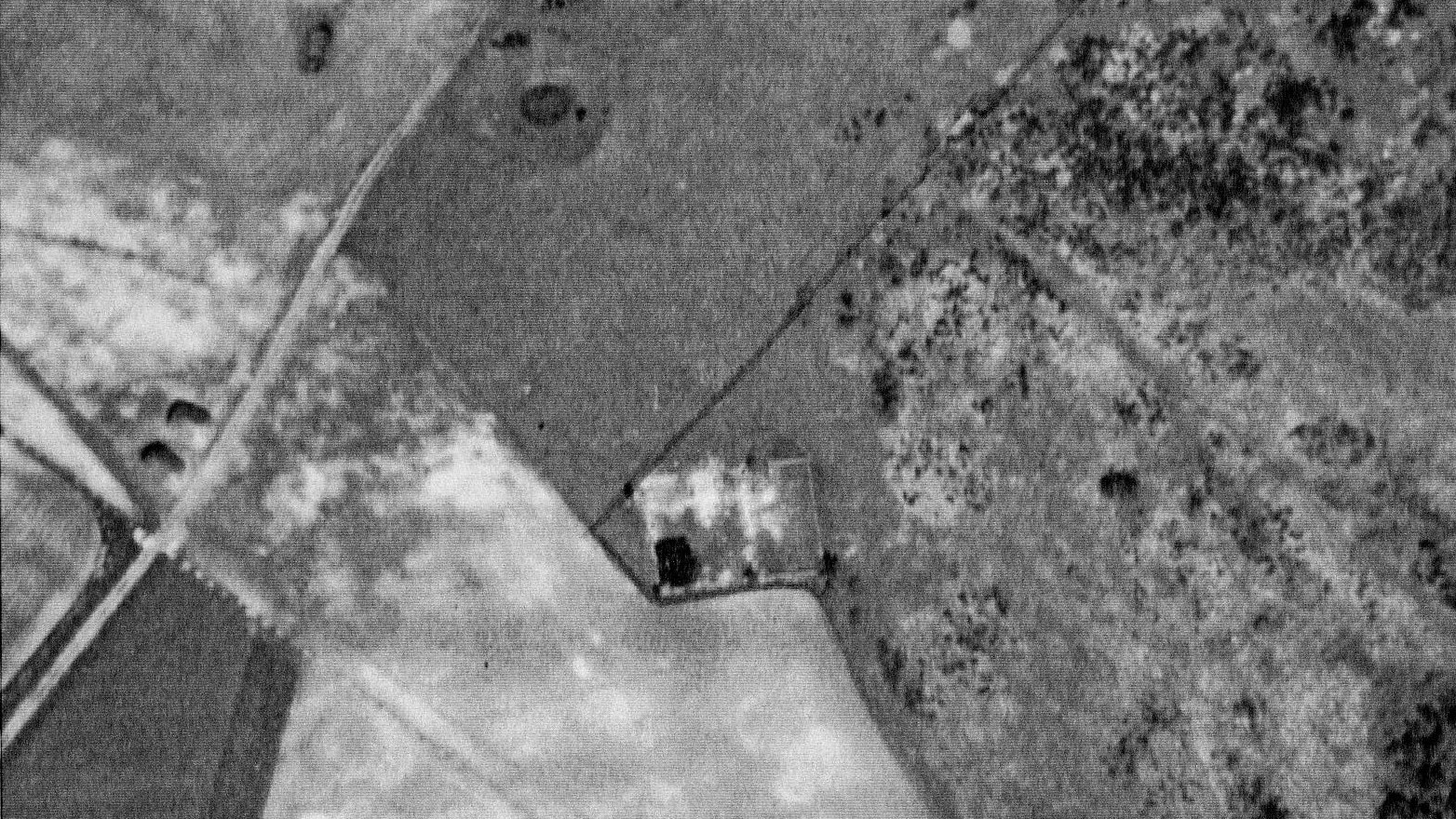
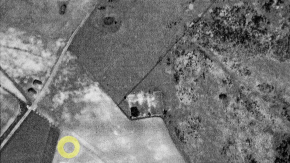
Our walk continued along the Juggs Road to its junction with the turn off to Castle Hill Nature Reserve on the right. But here we turned left, and got well and truly blasted by the hail which was now driven into our faces. But for me it was well worth the effort. Once clear of the ridge we headed diagonally across the field towards the Newmarket Plantation. This little walked path was a highlight of the walk, at least for me. It enabled us to identify the crash site of an American transport plane from the second world war. This was one of the worst accidents across the downs between Lewes and Brighton during the war, and nationally for this workhorse of a plane.
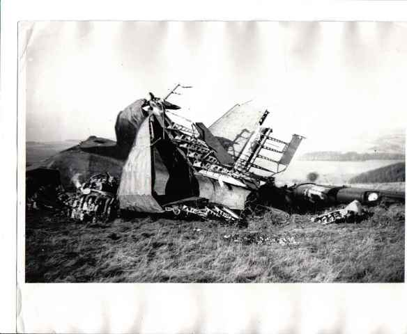
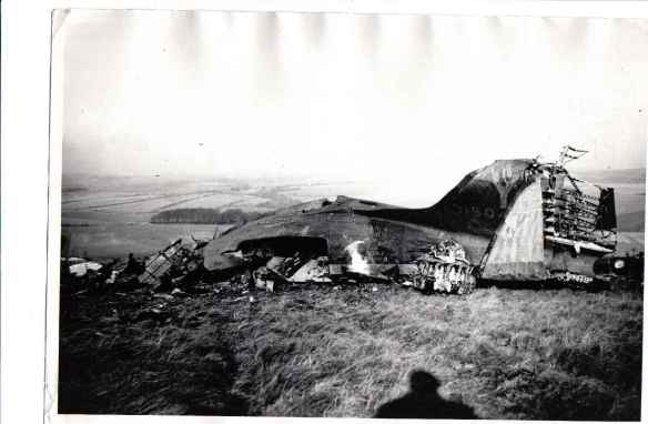
From the above two pictures we were able to line up the two woods and the field boundaries shown in the photographs and so were able to identify the approximate location of the crash. My photograph was taken in bad wind, rain, hail and relatively poor visibility. The original Douglas c-47 (Dakota) plane crash was apparently in similar conditions, though visibility on the 19th November 1944 in these hills was probably worse that day. Other than those who were there at the time, since then, the exact crash site seems to have been forgotten – until its rediscovery on our walk!
Reports on the Internet vary, and occasionally contradict each other, but between them I think I now begin to understand what may have happened.
- Date: 19th November 1944
- Local time: 1510 hours local
- The plane was a Douglas C- 47 (Dakota)
- Douglas (Model DC-3A-456) C-47A-80-DL
- Msn: 19512
- USAAF Serial number: 43-15046
- Coded: J8. Tail letter “Y”
- Unit: 439th Troop Carrier Group / 92nd Squadron. U.S.A.A.F.
- Mission: Bringing US servicemen back to the UK on leave, from France (A-35) Châteaudun to Newbury-Greenham Common RAF Station United Kingdom
- 25 killed, 5 survivors; the worst C-47 accident in the UK at that time.
The accident report stated that it had started to descend after just clearing a 645 foot (195 metre) hill. At the time of the accident, the ceiling was low with a maximum horizontal visibility estimated at 800 meters. In addition, the wind was blowing from the south at an estimated speed of fifteen knots. Witnesses saw the aircraft flying low from west to east and then vanish behind the ridge followed by an explosion. The aircraft was not overloaded and the crew were experienced.
From Key.Aero’s Historic Aviation Forum, a relative of one of the survivors stated that:
the electricity had gone out and although there were electritions on board they were not able to get it fixed. They did not have their lights to see the hill nor the equipment to know thier height or direction. I don’t know if there is any mention of this in any of the reports but that was about all he told us about it, that if they could have gotten it fixed the crash may not have happened.
List of sources:
- Aircrew Remembrance Society
- Sussex History Forum
- Bureau of Aircraft Accidents Archives
- Key.Aero Historic Aviation Forum
Baldy’s Wood

From the crash site we walked into Baldy’s Wood, otherwise known as Newmarket Plantation, where we sought shelter from the elements, though not from the ghosts of the past. However, just before we entered, the sun – glimpses of which had been seen to our south, north, east and west – made just a very brief but welcome appearance.

It has been called Baldy’s wood by locals because, on the day of David Baldy’s funeral:
a discovery was made which was supposed to have a connection with the murder of Baldey. It appeared that the police, whilst searching in the plantation where part of the gun was found, came across a new-dug cave with a very narrow opening, but sufficiently large to hold two or three men. A pick-axe and a hammer were the sole contents of this mysterious hole, though there was no evidence to show by whom the excavation was made or to what use it was to be put. It was of course suggested that Brown had made the hole intending it as a grave for his victim, and that subsequent events thwarted the carrying out of that part of his purpose. This, of course, was but a popular interpretation of the discovery.
Brighton Guardian Newspaper, 17th October 1868.
Exiting the wood, the sun had deserted us, and we made our somewhat damp way back towards our start at the car park immediately north of Woodingdean, via the cycle path along the Falmer Road. On the way back I told of more history; of a medieval deer park; of Saxon and Bronze age burial mounds; and the faint traces in a ploughed field opposite Upper Bevendean Farm of Cambridgeshire Farm, all that remains of my mother’s family home before they moved to Newmarket Farm at the start of WW2. Understandably though, my fellow travellers may have been close to hypothermia by this point, so I am not sure how much of what I said was being heard by then!!
Next Historical Healthwalk
My next guided history walk is in February. Whilst the days will be slightly longer, it will still be winter, so please dress warmly and join me on a tour of the ambitious plans and material legacy of the German American entrepreneur, Oscar Selbach, involving Woodingdean and Balsdean. Of course, prehistory, Medieval Balsdean’s manor and chapel and their ultimate destruction during the second world war will also be covered. Meanwhile, Happy Christmas!!

3 replies on “Newmarket Hill Healthwalk; Life and Death on the Downs!”
[…] Rainbow west of Newmarket Plantation. A moment of joy on a dark and stormy history walk – December 2019. […]
In retrospect, I was close to the Dakota crash-site location (in the right field), but my photograph does not quite align with the original. The actual site was a little further to the east (perhaps a hundred yards).
[…] visit to the site of the crash this year as I had hoped. I have previously written of it here and here. A few years ago I was privileged to speak to two eye-witnesses. Included below are some pictures […]