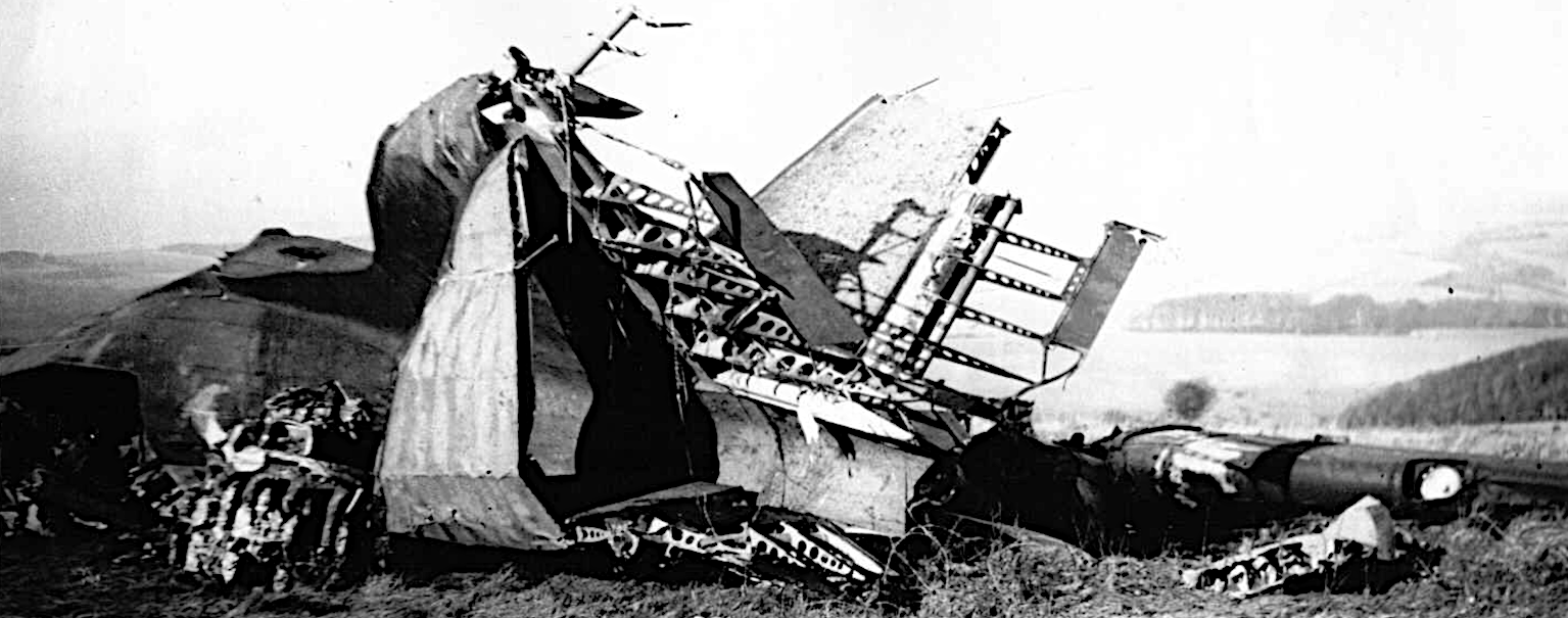
This year marks the 80th anniversary of D-Day. A crucial element of our success was an American workhorse transport plane, the Douglas C-47, otherwise known as the Dakota. Some five and a half months after our initial invasion, on Sunday 19th November 1944, a routine transport of mostly American troops from France ended in disaster, immediately north of the Balsdean Downs — almost exactly midway between Brighton and Lewes. It was the worst recorded plane crash on British soil to that date.
A technical report stated:
Douglas (Model DC-3A-456) C-47A-80-DL, msn 19512, USAAF serial number 43-15046, crashes at Lewes, Sussex, England, at 1510 hours local. The aircraft strikes a hill while flying in low overcast, explodes and burns; 25 of the 30 people aboard are killed.
The exact location of this air-crash appears to have been lost in recent years. Based on photographs it can be identified as being approximately 140 metres south-southwest of the southern edge of Newmarket Plantation, on the north side of the Newmarket Hill ridge, at a point from where Balmer Farm is (more or less) in line with the centre of Cranedean Plantation and the western edge of Newmarket Plantation (TQ 3677 0771). One of the first to arrive at the accident site was a friend’s mother driving an ambulance, as well as schoolboys from Woodingdean who’d seen the flames from over the hill. At the time it was well reported in the press, and various Internet sources have provided further details.
It was stated that the USAAF (439th Troop Carrier Group) military flight departed Chateaudun Airport (LFOC), France and was destined for Newbury-Greenham Common RAF Station (EWY/EGVI), United Kingdom. It was carrying 25 passengers (23 personnel of the 92nd Troop Carrier Squadron, 1 from Group Headquarters, 9th Air Force Troop Carrier Command) and 2 French civilians), 4 or 5 crew, as well as 13 type B-4 bags and all personal equipment. Aircraft was not believed to have been overloaded.
They encountered poor weather conditions on route. At the time of the accident, the cloud ceiling was low with a maximum horizontal visibility estimated at 800 meters. In addition, the wind was blowing from the south at an estimated speed of fifteen knots. It was elsewhere reported reported as flying at minimum altitude with minimum visibility — apparently a not uncommon occurrence — and that in attempting to descend, after clearing a 645′ hill, the aircraft probably was forced into the ground by the turbulent weather (or crashed into cloud-shrouded Newmarket Hill at a height of 600 feet (180 m) [though I prefer Castle Hill, for reasons given below]). The aircraft was being flown by an experienced crew and at such a low altitude, an unexpected downdraught might have forced the aircraft down before the crew could react to and counteract it (this tallies with the wind direction and topography based on my proposed crash location given above). According to a survivor onboard there was an electrical failure so: “They did not have their lights to see the hill nor the equipment to know their height or direction”. Another report gives the flight direction as being from England to France (I believe this may be wrong; see below). It burst into flames after crashing, and wreckage was strewn over a wide area. ARP workers ran 2 miles to the crash site (the distance from Woodingdean ARP First-Aid Post) and rendered what assistance they could.
| Crew: | |||
| Pilot | 1st Lt. Donald Q [O] Reid | USAAF | Killed |
| Navigator | T Sgt. Walter J James | USAAF | Severe burns |
| Sgt. Bryce D Hacking | USAAF | Burns and other injuries | |
| Sgt. Orazio R Toglia | USAAF | Burns and other injuries | |
| Cpl. Eric Ackerman | USAAF | Burns and other injuries | |
| Passengers: | |||
| 92nd Transport Squadron: | |||
| Pilot | 1st Lt. Roy L Gritz | USAAF | Killed |
| Navigator | 1st Lt Stanley E Lis | USAAF | Killed |
| Pilot | 2nd Lt. Russell W Barron | USAAF | Killed |
| Crew Chief | T Sgt. John H Young | USAAF | Killed |
| Crew Chief | T Sgt. Howard F White | USAAF | Killed |
| Glider Mech | S Sgt. Donald S Horstick | USAAF | Killed |
| Instr. Specialist | S Sgt. James H Holly | USAAF | Killed |
| Crew | Chief S Sgt. Arthur M Hackett | USAAF | Killed |
| Cook | Sgt. Barbato C D’Andrea | USAAF | Killed |
| Engineer | Sgt. Joseph H Alba | USAAF | Killed |
| Glider Mech | Sgt. Jake E Hesser | USAAF | Killed |
| Baker | Sgt. Felix R Sobkowiak | USAAF | Killed |
| Engineer | Sgt. William Hickson | USAAF | Killed |
| Glider Mech | Sgt. Sherman W Miller | USAAF | Killed |
| Glider Mech | Sgt. Harold F Mills | USAAF | Killed |
| Transport | Cpl. Richard M Jones | USAAF | Killed |
| Engineer | Cpl. Paul A Kokko | USAAF | Killed |
| Engineer | Cpl. Charles W Evenick | USAAF | Killed |
| Refuel. Unit | Pfc. Byron G Peacock | USAAF | Killed |
| Transport | Pvt. Roland P Lariviere | USAAF | Killed |
| Engineer | Pvt. Frank R Mix[n]er | ||
| 9th Air Force Troop Carrier Command | |||
| Group Headquarters | Unidentified | USAAF | Killed |
| Unidentified | Unidentified | Frenchman | Killed |
| Unidentified | Unidentified | Frenchman | Badly injured |
One report gave the accident as occurring 5 km (3 miles) NE of Brighton. This is more or less correct only if measured from Black Rock, the eastern most part of urban Brighton, not from the town centre. I believe that this, the references to Newmarket Hill, and the IWM photo notes, may have led people to have misidentified the site and orientation of the crash. The photographs clearly show the tail pointing approximately eastwards, strongly indicating the flight path to be more or less from the east, westwards. Chateaudun Airbase is to the SSE of the crash site, and RAF Greenham Common, to the NW. A direct route would have taken them over considerably more open water of the English Channel, which may have been an issue if flying in low visibility without instruments. If I am right, its flight path led it to encounter turbulence whilst crossing Castle Hill, approximately 1 km to the east of Newmarket Hill.
https://www.google.co.uk/maps/@50.8513355,-0.056931,21a,35y,316.41h,79.05t/data=!3m1!1e3
References:
- Forum members (2007–2010) USAAF C-47 Crash Near Brighton, Key.Aero, Historic Aviation Forum: https://www.key.aero/forum/historic-aviation/78389-usaaf-c-47-crash-near-brighton
- David King and Melvin Brownless (2014) 19.11.1944 92Sdn/439TCG Douglas C-47 43-15046 1/Lt. Reid: Location: Near Falmer, N of Brighton, East Sussex, England, Aircrew Remembrance Society:
https://aircrewremembrancesociety3.com/Aircraft-Losses/USAAF-Losses/U.S.A.A.F.Losses-1944/page-61/ - Aviation Safety Network (2021) 19441119-0:
https://aviation-safety.net/database/record.php?id=19441119-0 - Derby Evening Telegraph (1944) Dakota Crash: 26 U.S. Soldiers Die, Monday, November 20, 1944.
- The Western Morning News (1944) Dakota Troop ’Plane Crash, Tuesday, November 21, 1944.
- Nottingham Evening Post (1944) Dakota Plane Crash, November 20, 1944.
- Gloucestershire Echo (1944) 26 Die in U.S. ’Plane Crash, Nov 20, 1944.
- The Evening News (1944) Army Transport Plane Crashes Near Brighton, November 20, 1944.
- Bureau of Aircraft Accidents Archives (2021) Crash of a Douglas C-47A-80-DL in Lewes: 25 Killed: https://www.baaa-acro.com/crash/crash-douglas-c-47a-80-dl-lewes-25-killed
- IWM (2021) UNITED STATES ARMY AIR FORCES (USAAF) IN BRITAIN, 1942-1945, IWM FRE 11778:
https://www.iwm.org.uk/collections/item/object/205371817 - IWM (2021) UNITED STATES ARMY AIR FORCES (USAAF) IN BRITAIN, 1942-1945, IWM FRE 11777:
https://www.iwm.org.uk/collections/item/object/205371816 - KSH (2011) 43-15046 – Douglas C-47A crash at Falmer 19.11.44, South-East History Boards > Aviation > Military Aircraft Incidents (allied forces – wartime): http://sussexhistoryforum.co.uk/index.php?topic=1441.0
- Aerial Visuals Airplane Dossier (2021) Airframe Family: Douglas DC-1 / DC-2/R2D / DC-3 Dakota / C-47/R4D: https://aerialvisuals.ca/AirframeDossier.php?Serial=178870